
Apricale: A walk through a medieval hilltop village
Setting and getting there
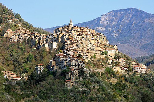
Apricale is a steeply built village in the western hinterland, its houses arranged in rings along a hillside. The medieval village center, which has been preserved, was first mentioned in documents in 1092 as Avrigallus. Its elevated position and compact layout make Apricale a place for a leisurely stroll rather than a quick roadside visit. Winding roads climb up from the coast; Bordighera or Ventimiglia make good bases, while an overnight stay inland leaves more time to explore the surrounding mountain villages. The coastal railway serves the shoreline corridor; Apricale lies above the coast and requires a separate drive up into the hills.
A walk through the village and its churches
Start at the lower entrance and follow the lanes uphill. The route climbs quickly; narrow passages, stairways and arches reveal the village’s ring-shaped layout. At the top is the piazza, with the castle and the two churches that define the square. At the Castello della Lucertola, the remains of a square 12th-century tower and sections of the outer walls mark the upper end of the walk.
On the square, it is worth visiting the parish church of Purificazione di Maria Vergine, with its mosaic floor. Opposite, the Oratory of San Bartolomeo preserves an altarpiece dated 1544, featuring the Madonna della Neve, as well as a depiction of Saint Anthony. To extend the walk, continue to the cemetery and the church of Sant’Antonio Abate: this small, single-nave chapel has a Romanesque-style apse and 15th-century frescoes. Santa Maria degli Angeli is also located at the village entrance, its walls and vaults covered with 15th-century frescoes. The result is a varied route that takes in not only the castle, but also religious art and local history.
Apricale and its surroundings
Apricale is also a good place to appreciate the terraced landscape of the hinterland. Dry-stone walls support terraces planted with olive groves and other crops, while chestnut and pine forests grow higher up. As a result, narrow passages alternate with open views across the slopes as you walk through the lanes. The village center reached roughly its present extent in the late 16th century; the older core is dated to the 13th and 14th centuries. This layering is easy to follow on the walk from the lower entrance to the castle square.
The route through the narrow lanes includes stairways and steep sections, so wear sturdy shoes and allow plenty of time. The village can be combined with Dolceacqua or Perinaldo as part of a day trip along the mountain roads. For regional context, see the overview of the Province of Imperia; the page on the Riviera dei Fiori explains the relationship between the coast and its hinterland. The advice on driving is useful for trips to the hill towns, while the railway overview covers travel to the coast. Find a suitable base through accommodation in Liguria; as a landscape theme, the Taggiasca olive connects many villages in this area with their terraced slopes.

